CASE STUDIES
Corinthian Park, Cheltenham - Flood Risk & Surface Water Strategy
For Corinthian Park, Cheltenham, Enviren’s FRA shows that a mixed residential–commercial scheme (up to 60 dwellings and 550 m² flexible space) can be safely delivered on a site that is nominally at risk from surface water flooding.
By carefully analysing the wider catchment, modelling flows through the western ditch and culvert system, and then re-profiling that ditch to increase capacity and storage, the design:
- Keeps the new development outside significant pluvial hazard,
- Maintains or betters pre-development flow conditions, and
- Ensures no increased flood risk to neighbours or downstream receptors.
The FRA provides a clear, policy-compliant technical justification for granting planning permission, contingent on the specified mitigation being implemented.
Project Overview
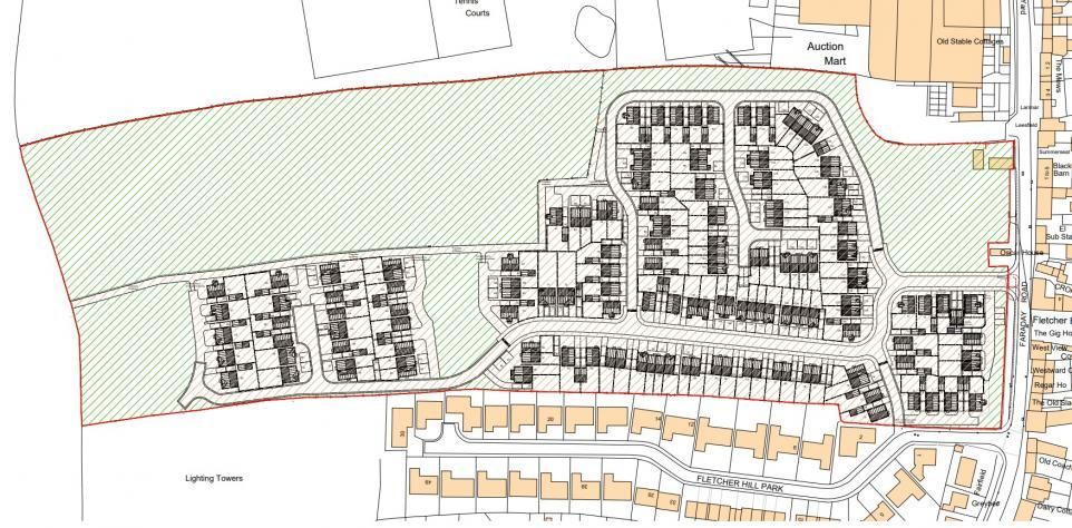
Enviren prepared a Flood Risk Assessment (FRA) for Revival Developers Limited to support a planning application at Corinthian Park, Cheltenham. The scheme comprises:
- Up to 60 dwellings, and
- Up to 550 m² of flexible commercial space, together with associated infrastructure and works.
The FRA is explicitly prepared in line with the NPPF, Planning Practice Guidance and local policy (Cheltenham Borough Council SFRA, GCC LFRA etc.).
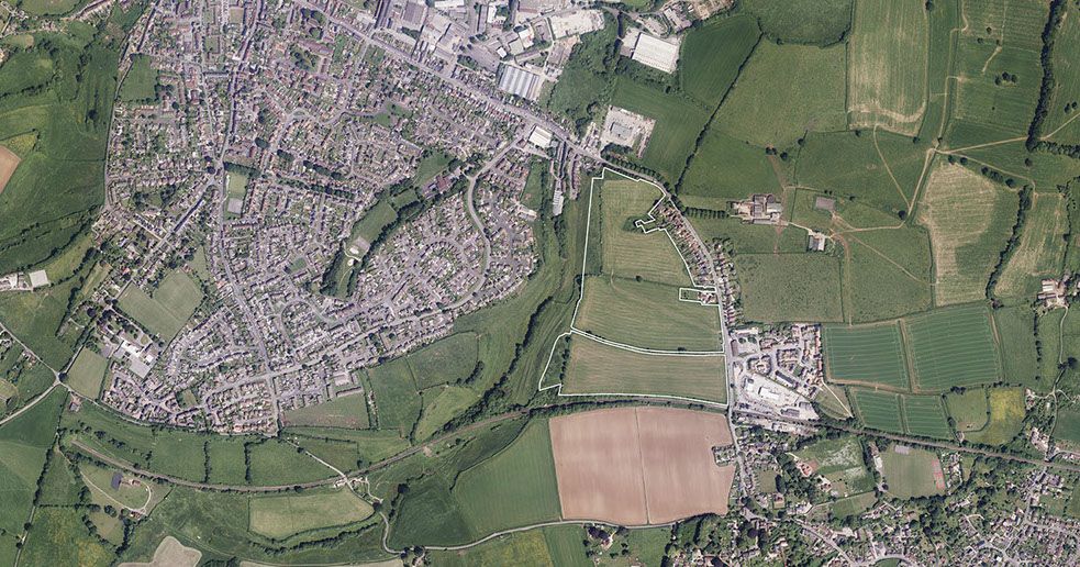
Site Location & Existing Conditions
Location
The site is:
- On the western edge of Cheltenham,
- Located between the A40 and North Road West,
- Approximately 4.41 km west of Cheltenham town centre and 7.35 km east of Gloucester city centre.
- The existing site is greenspace (grassland with some stockpiles), about 1.650 ha in area, bounded by roads to north and south, a commercial estate to the east and gardens/dwellings to the west.
Outline Hydrology
Topographical analysis (SCALGO) shows:
- Runoff from the majority of the site flows west into a minor watercourse off Badgeworth Road,
- That watercourse then flows north and west, ultimately discharging to the River Severn via Hatherley Brook.
Ground Conditions
The site is underlain by the Charmouth Mudstone Formation (mudstones and shales with limestone bands).
HR Wallingford’s greenfield runoff tool indicates:
- SPR = 0.370 (SOIL type 3) → slightly impermeable soils.
Sources of Flood Risk
The FRA considers fluvial and pluvial risk using EA, local authority and SCALGO mapping.
Fluvial / Tidal (River & Sea)
Strategic Flood Risk Assessment mapping shows the development parcel lies entirely in Flood Zone 1, i.e. very low risk of river or sea flooding.
Pluvial (Surface Water) – Primary Risk
EA surface water maps and detailed SCALGO modelling identify the site as being at risk principally from pluvial flooding, with flow paths crossing the land towards the west.
The FRA therefore focuses on:
- Overland flow routing through the site,
- Capacity of the existing and proposed ditch along the western boundary, and
- Ensuring the development does not increase flood risk downstream.
Catchment & Hydraulic Analysis
The report includes:
- Catchment analysis and a delineated flow-path catchment contributing to the western ditch,
- SCALGO wider topographic mapping to understand regional flow routes,
- A hydrograph-based model of flows to the culvert/watercourse system.
Model outputs (Flow+ / Innovyze) test a range of storm durations (15–1440 minutes) for the 1 in 100 year + 40% climate change event, with mass balance close to 100%, and show the culvert and downstream system can convey the design flows when the ditch is appropriately sized.
Mitigation Strategy
Western Ditch Regrading & Capacity
A key mitigation measure is to widen and regrade the base of the existing ditch on/adjacent to the western boundary to provide:
- Sufficient capacity for pluvial flows from the catchment.
- Level-for-level floodplain compensation relative to current RoFSW-identified storage.
- Existing ditch capacity calculations.
- Proposed ditch capacity after regrading, showing an increase in flow capacity from ~0.32 m³/s to ~0.76–0.85 m³/s for the 1 in 100 year + 40% CC event (derived from cross-sectional areas in the Northern Ditch Sections drawing).
Managing On-Site and Downstream Risk
The FRA concludes that:
- The widened ditch provides sufficient storage and conveyance to protect both the development and downstream receptors from pluvial flooding.
- The drainage strategy ensures no increase in flood risk to the wider catchment by managing surface water through the land parcel in a controlled way.
Overall Flood Risk Outcome
The conclusion section summarises post-mitigation risk as follows:
- Fluvial: Very low – site is in Flood Zone 1 and not influenced significantly by main rivers.
- Pluvial: Low–medium risk without mitigation, reduced to acceptable / low risk by ditch widening and flow management.
The FRA states:
“In compliance with the requirements of the National Planning Policy Framework, and subject to the mitigation measures proposed, the development could proceed without being subject to significant flood risk. Additionally the development will not increase flood risk to the wider catchment area owing to suitable management of surface water passing through the land parcel.”
And:
“Providing the flood mitigation strategies outlined in this document are implemented, flood risk should not prevent approval being granted to this development.”
PROJECT DETAILS
CLIENT
Hinton Group
LOCATION
Cheltenham
OFFICE
Bristol
COMPLETED
2025
More Case Studies